Sector
Environment and Animals
Objectives
Fundraise
Raise Awareness
Visualize data on a map
Photo Credit
Chief Almir and the Surui tribe of the Amazon
In our recent history, our land has been extremely threatened by violence Polonoroeste program, corruption and failure of government agencies and the unauthorized invasion of random people, such as timber and mineiros.
We, the Paiter, along with the people of the forest, we are determined to maintain our culture and our living environment.
Challenge
The Surui people of the Brazilian Amazon had their first contact with outsiders in 1969, introducing them to the modern world and all of its associated issues. Years later, this contact expanded to their land, as it became threatened with deforestation by illegal loggers.
Story
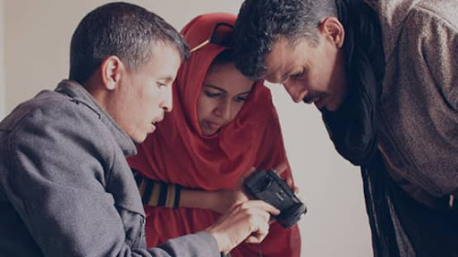
When Chief Almir first glimpsed Google Earth on a visit to an Internet café, the indigenous chief immediately grasped its potential for conserving the heritage and traditions of his people. He invited Google to train his community in recording the stories of tribal elders. Surui tribe members learned to create YouTube videos, geo-tag content, and upload it to a “cultural map” on Google Earth in order to share their unique history and way of life with people all around the globe.
Meanwhile, the deforestation of the Brazilian rainforest is not only having a devastating effect on indigenous people and the local economy, but also destroying biodiversity and contributing to greenhouse gas emissions. For these reasons, Chief Almir believes that the issue of illegal logging on Surui territory is important to everyone on the planet and he’s harnessing the power of Google Earth to spread the word.
In 2009, Google visited the Surui people again and taught them to use mobile phones and Open Data Kit to record instances of illegal logging. Tribe members can capture GPS-located photos and videos for immediate upload to Google’s mapping tools, so today's perpetrators of illegal deforestation literally have nowhere to hide; anyone anywhere can see the effects of their work with their own eyes.
“Since the Surui and other indigenous people were given training tools by Google, our land has received more visibility. All the information is shedding light on the invasion of our land ... and giving our people the responsibility for their own future.”
Chief Almir, San Francisco Chronicle
Impact
Now, the Surui are using Open Data Kit to monitor their forest’s carbon stock to trade on the carbon credit marketplace, which will allow them to build a sustainable future for their territory.